Dynamics of a post-industrial cross-border region
Located along the northern boundary of France's Lorraine region, the Pays Haut Val d'Alzette area borders the Grand Duchy of Luxembourg. During the past two decades, this c federation of municipalities has undergone significant economic changes. The loss of its steel and mining industries has left a significant mark on the region. At the same time, the neighboring Luxembourg economy expanded in opportunity and appeal, creating many new jobs for the inhabitants of the frontier areas, without either country genuinely taking this dynamic into account in their public policies.
Today, the envisioned development project for this region aims to take full advantage of this paradoxically promising situation. It would be an opportunity for attracting new businesses to the area, as well as providing a living environment and services to both its current and future populations.
In 2011, an Operation of National Interest (abbreviated OIN in French) was set in motion for the region. OINs are French legal governmental initiatives that are usually put in place for a vast metropolis. In this atypical case, however, the OIN here aims to establish a high-quality living environment at the level of an entire region. This process of territorial transformation depends largely on the understanding and consistency of its landscape structures. The overall strategy is multifaceted, endeavoring to diversify urban functions, reintegrate brownfield sites, renew old city centers, improve the quality of residential space for both densely populated and more suburban areas, all while accounting for the region's natural spaces, historical sites, and variety of flora and fauna, in need of protection. The second particularity of the Alzette-Belval OIN project: it runs cross-border. The French side of the project is dependent on, but also complementary to, the Luxembourg side of the project, centered on Esch-Belval.
Bringing to light and magnifying existing landscape structures
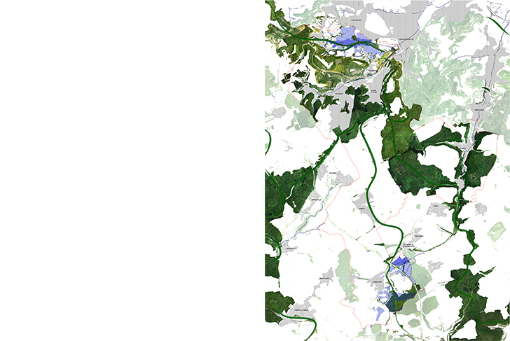
Spread across a plateau, the Alzette and Kayl valleys, and the Beler plain, the 7,294-hectare region brings together contrasting urban and rural landscapes. The mining and steel activities of the past were effective in imposing a spatial logic on the ongoing process of urbanization. They also left a profound mark on the region's geographical relief and landscape. Now fallen into disuse, these sites have spontaneously been colonized by pioneer vegetation to such an extent that today they present a new landscape structure of impressive dimension.
By studying the entirety of the environmental and landscape structures already in existence, the masterplan, with its accompanying plan of interventions, aims at better revealing and accentuating these structures for the benefit of the greater region. This contextual approach works in highlighting the natural, cultural, and patrimonial aspects of the abandoned sites, while encouraging one to invert the way one sees them. Both the large natural green formations of the region, as well as the “artificial” geography of these reappropriated industrial sites become together the foundations of a larger territorial landscape framework.
To the north, the Beler plain extends all the way to Luxembourg. Located as it is to the side of what was the region's industrial center, it has remained an agricultural landscape whose unjoined plots of land are still partially separated by hedgerows. Here, the presence of numerous humid depressions has created an area of great ecological wealth. Continuing east, however, the relatively well-preserved nature of the landscape changes, as the plain becomes dotted with several considerable industrial brownfield sites, in Redange along the Luxembourg border.
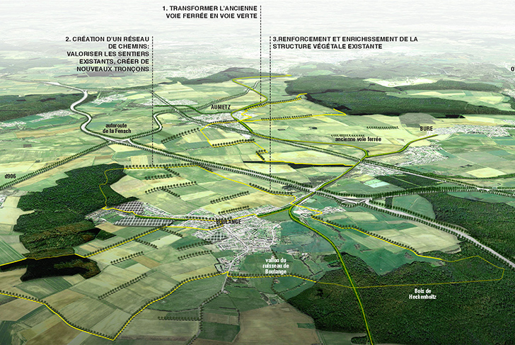
To the south, the plateau of open countryside is characterized by vast farmed expanses that are broken up by the traversal of linear infrastructure (highways and railways). Standardized with single-crop farming, the plateau is also occasionally dotted with spruce woodland.
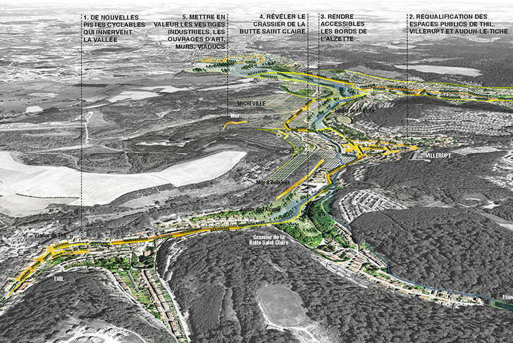
Where the higher country (Pays Haut) in the south meets the lower country (Pays Bas) in the north, the steep Alzette and Kayl valleys form wooded corridors that have been densely developed, cluttered now with brownfield sites and slagheaps.
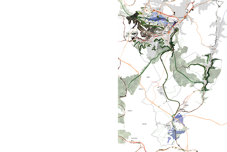
The whole region is cross-crossed by the old system of cavaliers, a series of private railroad links used by the mining industry. This system, long abandoned, and in places overgrown, has the potential for rehabilitation into a means of connection between the region's various components cited above.
Landscape configurations and planning challenges
Four large landscape configurations will structure the various settings and interconnections the overall project aims at bringing better to light.
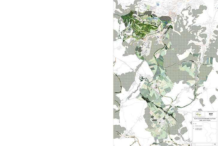
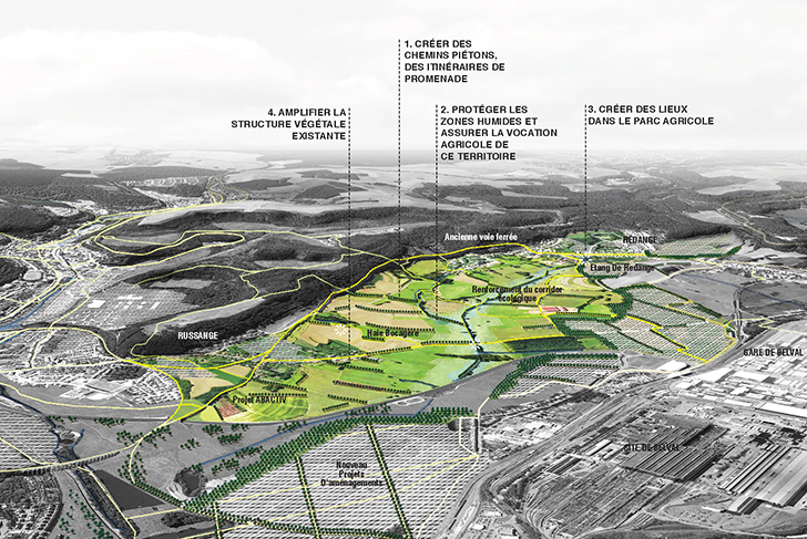
1. A cross-border agricultural park along the Beler plain
A large number of urbanization interventions have been concentrated at the edges of the Beler plain. Preserving this rural pocket with its ecological wealth (wetlands) requires the creation of an agricultural park that will meanwhile function as a bridging component between Luxembourg and the urbanized hillsides. With the opportunity of reexamining the relationship between city and countryside during the planning of the park, a certain diversity in its uses can be determined in advance, establishing an equilibrium of a new order between its productive, recreational, and ecological functions (with the creation of pathways alongside the plots of land, as well as observatories, reserved areas).
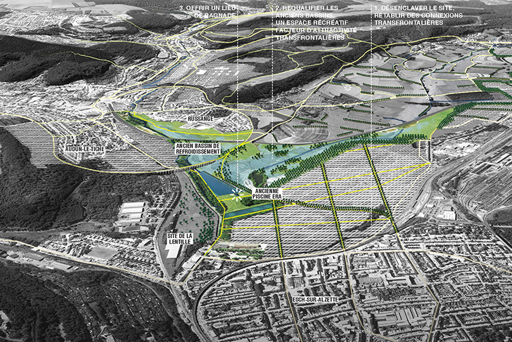
2. A park of basins
In Redange, a series of abandoned settling basin sites and an old open-air pool will connect into forming a unique water landscape at the point where Luxembourg and France meet. They will be rehabilitated into a recreational park hosting original programming. Over time, it will be recognized as a familiar and shared space, bringing French and Luxembourgers together.
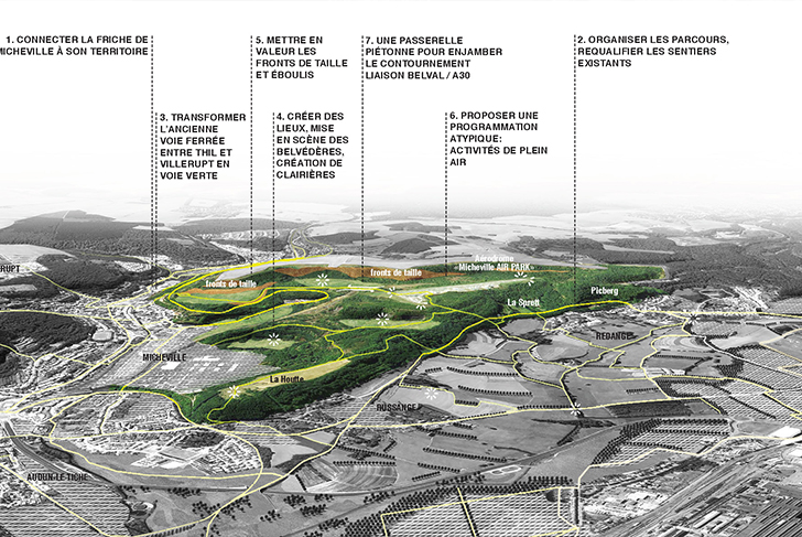
3. A naturalist park at Micheville
Abutting right up against the city of Thionville as it does, the Micheville brownfield site possesses a unique position and character. Reinventing it as a naturalist park dedicated to recreational and ecological purposes will provide the nearby suburban areas with new life. Flexible, and as far as possible reversible, interventions have been planned, along with open-air programming thought through as site specific, as well as an appropriate staging of the site's distinctive industrial remnants. Discerning work is required to connect the redeveloped site physically and visually with the surrounding urban context: determining the location of entrances, while subtly managing the interweaving of pathways between city and park.
4. A regional network of bikeable and walkable paths
Repurposing the old, abandoned, private railroad system, a green pathway network could be established across the entire region, organizing the means of transportation between the agricultural plain and the urbanized valleys. Along the plain, this network would present the opportunity for clearly tracing and defining the open spaces of continuous woodland, functioning in a similar fashion to those paths that once ran alongside and framed old roads, playing a role in the discovery of the landscape. Connecting the forest areas fragmented by agricultural activities, the network would be above all a means for restoring corridors of flora and fauna that have long disappeared. Within the urban environment, this network creates an opportunity for rethinking the typology of the streets, with the introduction of vegetation and soft modes of transport alongside them.
EPA Alzette Belval
MDP Michel Desvigne Paysagiste (lead consultant)
EGIS
Ville Ouverte
7300 ha