The Seine-Nord Europe Canal project represents the French section of the greater European Seine connection. It will allow for significant development along the axes between Le Havre-Paris-Lille-Dunkirk and Le Havre-Paris-Lille-Rotterdam-Antwerp (where traffic saturation has been reached). The project is part of a policy by the public authorities favoring a modal shift, one which participates in the implementation of sustainable development goals. It will bring economic development to all French regions covered by its route (Haute-Normandie, Ile-de-France, Picardie, and Nord-Pas de Calais), and will constitute an opening for transporters and carriers to the European market.
Working within a group of selected consultants, we were given the task of delivering within a very short period of seventeen months a preliminary draft of the project for the government, ready for the formal declaration of public utility required by French law by the end of 2007. Beyond providing the analytic components that allow for choosing between the variations in routes, the landscape masterplan also provides the opportunity of defining the aesthetic principles necessary for the creation of the canal's built landscape.
In a very simplified manner, the general vision for the Seine Nord canal's built landscape can be summarized as follows: the area surrounding the canal constitutes a sort of gardened promenade, with vast landscapes of flowered meadows interspersed with trees. These meadows change over time and mark the passage of the seasons. Surrounding the space of the promenade, a very spacious and open agricultural landscape is preserved, dotted with villages and woods. Certain of the wooded areas near the canal essentially become parks, enhancing the appeal of the promenade for residents as well as for visitors.
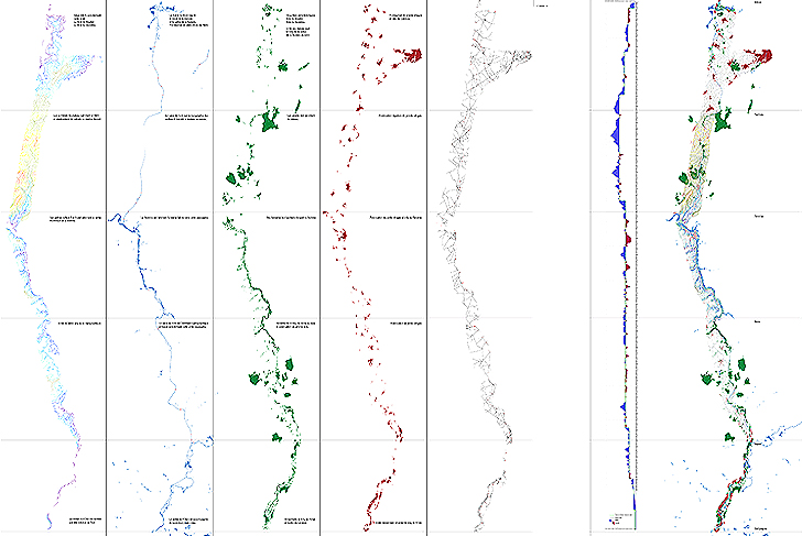
The principal issues the project addresses concern the significant transformations of the topography, the potential plant covering of the large soil landscaping works, and the transformation of the agricultural plots of land. These issues are each approached in precise terms depending upon the various scales considered. As a result, the physical makeup of the project design is not homogeneously determined from one scale to another.
For example, in terms of moving earth, we favor conceiving contours, including those with very sizeable deposits of soil, that are the most consistent with the actual geomorphology of the sites the project traverses. On a large scale, this translates to a slight amplification of the existing topographic undulations. On a smaller scale, the small valleys and their branches should not be significantly affected or “distorted”. Contrary to our approach concerning the large undulations, we believe here artificial works should be explicitly introduced, contrasting with the preserved natural forms of the valleys the project crosses. In this way, a dike that crosses a valley is acceptable, whereas a small valley that “naturally” closes would be incomprehensible.
Similarly, at the territorial scale, the necessity of a plant covering for the substantial moving of soil intrinsically carries the risk of creating a kind of continuous bulge lacking coherence with the landscapes. We propose the development of ecological flowered meadows, varying depending upon the circumstances regarding the soil, the slope, and the orientation. These meadows are above all a way of managing the non-agricultural surface areas. They also take into account the existing sporadic wooded areas which require being highlighted in their turn.
One of the main challenges of the exercise is almost paradoxical at two levels: these gigantic artificial landscapes, perceptible at the level of the pedestrian, are nonetheless nearly invisible on a map when the focus, on the contrary, lies in preserving the natural logic of the geomorphology.
VNF Voies Navigables de France
MDP Michel Desvigne Paysagiste
Coyne et Bellier, engineers
Tractebel, engineers
Compagnie Nationale du Rhône
Technum, engineers
105 km long